Working group: Cultural, political and digital geographies (Glasze)
The research projects in the working group Cultural/Political/Digital Geographies at the Erlangen Chair of Cultural Geography (Glasze) share a discourse-theoretical perspective on social spaces that understand them as always produced in a specific way, potentially controversial and in this sense as cultural and political.
We develop contributions to the theoretical and methodological advancement of discourse studies in geography. In doing so, we are guided by a “broad” concept of discourse that goes beyond language and symbols.
Our research can largely be categorised into three areas:


Resilienz digitaler Infrastrukturen – Geopolitische Konflikte um Internet-Routing
(Third Party Funds Single)Term: 1. October 2024 - 31. March 2028
Funding source: Bundesministerium für Bildung und Forschung (BMBF)Open geospatial data at the intersection of digital commoning, digital humanitarianism, and digital capitalism: Transformations and tensions in OpenStreetMap
(Third Party Funds Single)Term: 1. August 2024 - 1. January 2026
Funding source: DFG-Einzelförderung / Sachbeihilfe (EIN-SBH)
URL: https://digital.geo.uni-halle.de/open_geosm/This project examines transformations and tensions in the field of open geospatial data. It’s starting point is the growing role of commercial and institutional actors in OpenStreetMap (OSM). In the context of the OSM open geospatial database – a project that relies heavily on the voluntary engagement of local communities of mappers – these developments have significant implications for geospatial data.
The research project starts from the premise that there is a tension between the ethos of OSM as a project that builds on local knowledge and practices of digital commoning, and concerns about the remote and extractivist practices of institutional actors. These concerns are particularly articulated by decolonial and feminist voices within the OSM community and raise questions about the power of mapping as well as organisational issues of participation, polyphony and data sovereignty.
The research project has three aims: 1) to analyse the changing production and use of geographic knowledge and data in OSM, 2) to trace interactions, intersections and conflicts between the different groups of actors, 3) to examine the changing governance of OSM at the intersection of digital commoning, digital humanitarianism and digital capitalism.
These objectives will be addressed through two complementary case studies. The first study focuses on the strategies and policies of key institutional actors in OSM (e.g. commercial actors such as Meta and Microsoft, the Overture Maps Foundation, and the Humanitarian OSM Team). Of particular interest are the relationships, conflicts and tensions between these institutional actors and key actors in the OSM community. The second case study explores the practical interactions between local mapping communities and institutional actors at the local level. It focuses on the Philippines, a site where local communities of mappers interact, intersect and struggle with actors and concepts of digital platform capitalism and humanitarianism.
Politische Geographien materieller Internetinfrastrukturen
(Own Funds)Term: since 1. May 2023Geo-Data for the Digital Documentation of Human Rights Violations
(Third Party Funds Single)Term: 1. September 2022 - 31. August 2025
Funding source: Bundesministerium für Bildung und Forschung (BMBF)
URL: https://www.geographie.nat.fau.de/geo-daten-zur-digitalen-dokumentation-von-menschenrechtsverletzungen/The project "Geo-Data for the Digital Documentation of Human Rights Violations" (GeoDatRights) aims to a) use satellite-based remote sensing and social media data to investigate the destruction and military appropriation of educational institutions in war zones, and b) establish digital analysis skills in German-language human rights research over the course of the project. FAU already has a distinctive human rights profile and aims to expand it in a forward-looking way.
In the GeoDatRights project, we are testing the harnessing of satellite-based remote sensing and further (geo-)data esp. from social media for this purpose, building on interdisciplinary cooperation between human rights research in political sciences and geography to tap methodological expertise from digital geography for empirical human rights research.
Producing Syrian Refugees in Jordan: Syrische Migrant*innen in Jordanien nach dem EU-Jordan-Compact
(Third Party Funds Single)Term: 1. September 2019 - 30. June 2025
Funding source: StiftungenDas Forschungsprojekt untersucht Prozesse der Produktion & Konfiguration unterschiedlicher Subjekt- und Raumkategorien im Kontext von Flucht & Migration im nördlichen Jordanien. Dabei wird das nördliche Jordanien als dynamischer Grenzraum bzw. Grenzlandschaft verstanden, welches zunehmend mehr in den Fokus der europäischen Migrationspolitiken rückt. Im Zentrum stehen dabei derzeit verstärkt syrische Geflüchtete, welche mit mit einem System differenzieller Inklusion infolge verschiedener diskursiver und performativer Aushandlungsprozesse unterschiedlichster Aktuer*innen konfrontiert sind.
Untersucht werden Prozesse der sozialen, rechtlichen und ökonomischen Ein- und Ausschlüsse. Die dadurch entstehenden Prozesse der räumlichen und sozialen Fragmentierung können in diesem Zusammenhang als als Effekt von konkurrierenden Politiken und Strategien von biopolitischer Bevölkerungsregulation, identitätspolitischer Auseinandersetzungen, (externalisierter) Grenz- und Migrationskontrolle, ökonomischen Interesses, humanitären Logiken, alltäglichen Formen des (Über-) Lebens und widerständigen Praktiken konzipiert werden.
Politische Geographien digitaler Infrastrukturen
(Third Party Funds Single)Term: 1. November 2022 - 30. April 2023
Funding source: andere FörderorganisationEuropean Data Spaces between integration and exclusion. On the infrastructure of the Internet of European Values
(Third Party Funds Single)Term: since 1. October 2021
Funding source: StiftungenDas Vorhaben beforscht den Prozess der Entstehung europäischer (Cloud-)Infrastrukturen, welche die souveräne Digitalisierung von Staat, Industrie und Gesellschaft vorantreiben sollen. In diesem Prozess soll eine der wichtigsten Infrastrukturen des 21. Jahrhunderts – das Internet – ‚europäisiert‘ werden. Es ist zu erwarten, dass dabei dauerhafte Pfadabhängigkeiten und damit auch bleibende gesellschaftliche Realitäten geschaffen werden.
Darüber hinaus werden in der europäischen Internetpolitik, als einem der wichtigsten Politikfelder der EU-Kommission, Fragen über die Identität der Europäischen Union und ihre grundlegenden Werte und Normen (neu) verhandelt. Diese neuen Realitäten, Kräfteverhältnisse, Abhängigkeiten und Wertevorstellungen gilt es herauszuarbeiten und einer gesellschaftlichen Debatte zugänglich zu machen.
Mit seiner interdisziplinären, gesellschaftswissenschaftlichen Perspektive öffnet das Vorhaben den Blick für die unterschiedlichen Interessen im Feld und zeigt auf, welche Konflikte und Widersprüche im Prozess der Infrastrukturierung digitaler Souveränität auftauchen. Die Untersuchung dieses scheinbar nur verwaltungstechnischen Prozesses arbeitet seine immanent politischen Dimensionen heraus und zeigt auf, welche neuen Grenzen, Ein- und Ausschlüsse, Zentren und Peripherien dabei entstehen.
Auf diese Weise trägt das Vorhaben zu einem differenzierteren Blick auf die Gestaltung der digitalen Transformation in Europa bei und liefert Grundlagen für gesellschaftliche Debatten zur Frage: „Was für eine Digitalisierung und für wen wollen wir in Deutschland und Europa?“
FAU GeoExplorer - Tool for digitally supported excursions
(FAU Funds)Term: 1. January 2021 - 31. December 2023
URL: https://www.geographie.nat.fau.de/forschung/ag-glasze/fau-geoexplorer/In geography and many other disciplines (e.g., archaeology, art history, biology, geology), field trips enable on-site learning. Digital media can contextualize locations by providing additional information. In current e-learning solutions, however, the didactic potential of digitally supported excursions is only rudimentarily developed.
This is where the "FAU-GeoExplorer" project comes in: The tool already enables (1) a platform-independent use of media and (2) a didactically structured provision of (3) modular learning units for excursion sites. The GeoExplorer will be further developed step by step.In the Mirror of the European Neighbourhood (Policy): Mapping Macro-Regional Imaginations
(Third Party Funds Single)Term: 1. September 2020 - 31. July 2024
Funding source: DFG-Einzelförderung / Sachbeihilfe (EIN-SBH)
URL: https://imageun.eu/The European Union is in a phase of substantial spatial and social restructuring: its territory has increased through the accession of 14 Eastern and Southern European countries since 2004; it has given itself a new constitution in form of the Lisbon Treaty; it is trying to cope with a severe financial crisis and the rise of nationalism and autocratic appeal in and around it; and currently it has to work through the loss of a member for the first time in its history. Simultaneously, the EU’s neighbourhood is also undergoing severe transformations. Not only because the “neighbourhood” changes in form of accession to the EU or secession from it (Brexit), but also in light of geopolitical shifts, such as the conflict in Ukraine, the effects of the Arab revolutions (including the wars in Syria and Libya) and the power aspirations of Turkey, Russia, Iran and some Arab States. The socio-spatial shape of the entire macro-region around the EU, often termed the “European neighbourhood”, thus, has been changing substantially – and with it the relations between EU-members and non-members within this macro-region. Also beyond the EU and its neighbourhood, seemingly stable macro-regional orderings of the world are in flux. These transformations of global macro-regional ordering and the changing meanings of “Europe”, the EU and the relations with its “neighbours” are in the centre of this project. Against this background we propose to explore geographical imaginations of the socio-spatial shape of this macro-region and the spaces of interaction within it, focussing on five key countries in and around the EU (France, Germany, Turkey, Tunisia, and the UK) and covering three levels of geopolitical analysis (in higher education systems, amongst political stakeholders, and in agenda-shaping media outlets). In so doing we bring together the heterogeneous national and theoretical expertise of the involved researchers and will contribute to contemporary academic debates on macro-regionalization, Europeanization, the sociospatiality of the EU, and its international identity and role – including the relations with its neighbourhood and the socio-spatial shape of a larger (European) macro-region around it. More concretely, we pursue two key ambitions. Firstly, we seek to develop a comprehensive and dual comparative account of dominant geographical imaginations between five countries and three levels of geopolitical analysis decisive for shaping such imaginations. Secondly, and in addition to the academic output, we intend to not only study geopolitical agents on these levels but actively work with them for collectively developing visions on the future socio-spatial shape of the macro-region. As such, collaboration with fellow researchers, think tanks, political stakeholders and journalists is an essential and enduring part of this project that ensures broad public visibility and high political buy-in through the inclusion of these agents in the research process.Diskurse und Praktiken digitaler Souveränität in Deutschland, Frankreich und Europa
(Third Party Funds Single)Term: 14. May 2020 - 29. September 2020
Funding source: andere FörderorganisationExclusions in volunteered geographic information (VGI) - renewal proposal: Geodata from local experts? An examination of the assumption of localness in VGI by analysing the example of OpenStreetMap (OSM)
(Third Party Funds Single)Term: 15. January 2020 - 15. January 2021
Funding source: DFG-Einzelförderung / Sachbeihilfe (EIN-SBH)Volunteered geographic information (VGI), that is to say, the voluntary and non-paid collection of geodata within the interactive web 2.0, has been interpreted as a chance for giving marginalized voices access to the compilation and dissemination of geographic information. However, the idea that within the web 2.0 everybody could participate in the fabrication of geographic information has been rapidly questioned, pointing to the different social and socio-technical forms of exclusion. Yet, despite the rapidly growing importance of VGI for different fields, up to now there are only few and hardly any systematic empirical studies on the social and socio-technical backgrounds of VGI. This is the starting point for our research project which aims to reconstruct the fabrication of collaboratively assembled geodata. The project intends to uncover processes of marginalisation and exclusion and thus to analyse how social inequalities are inscribed in VGI and become reproduced through VGI. As a case study we look at the globally most popular projects of a collaboratively collected geodata bases, OpenStreetMap (OSM) and WikiMapia, within a regional context which is due to the multiple social disparities and political conflict lines particularly informative and empirically fertile: Israel/Palestine.Discourses and Practices of a "Digital Sovereignty"
(FAU Funds)Term: 1. March 2019 - 31. December 2022
URL: https://www.digital-sovereignty.fau.de/Digitale Geographien: Geodaten - Code - Gesellschaft
(Third Party Funds Single)Term: 1. November 2018 - 30. June 2021
Funding source: DFG-Einzelförderung / Sachbeihilfe (EIN-SBH)Stadt von rechts! Zur Frage rechter Stadtnarrative und deren Reproduktion in organisierter politischer (Alltags-)praxis.
(Third Party Funds Single)Term: 1. August 2018 - 31. July 2021
Funding source: StiftungenDigitale Geographien - Lehr- und Forschungskooperation zwischen der Kulturgeographie an der FAU Erlangen-Nürnberg und Universitäten in Kanada (Ontario & Québec)
(Third Party Funds Single)Term: 6. March 2018 - 31. December 2018
Funding source: Bayerische Forschungsallianz (BayFOR)The ‘European Capital of Culture’ programme between local and international cultural policies: an observation and analysis of debates and strategies employed by German cities when applying to be European Capital of Culture 2025
(Third Party Funds Single)Term: 15. October 2017 - 31. December 2019
Funding source: Deutsche Forschungsgemeinschaft (DFG)
URL: https://www.geographie.nat.fau.de/dfg-projekt-zum-programm-kulturhauptstadt-europas/Die Transformation des menschlichen Wissen in strukturierte Daten – soziale Dimensionen von Wikidata
(FAU Funds)Term: 1. October 2017 - 31. May 2018Konzeption eines Web 2.0 Kartographie Moduls für das Science Center Experimenta (Heilbronn)
(Third Party Funds Single)Term: 14. December 2016 - 31. March 2017
Funding source: IndustrieZur ‚Lesbarmachung‘ und Produktion von Kalkulierbarkeit städtischer Räume: ein kritischer Blick auf Smart Cities
(Third Party Funds Single)Term: 1. October 2016 - 30. September 2019
Funding source: StiftungenIm Rahmen desPromotionsvorhabens beschäftigt sich Christian Eichenmüller mit der Lesbarkeit und Kalkulierbarkeit städtischer Räume, die im Kontext der Digitalisierung städtischer Infrastruktur einen neuen Schub erfährt. Das Ausmaß von ‚Lesbarmachung‘ und Kalkulierbarkeit städtischer Räume ist nicht einfach gegeben, sondern wird aktiv produziert. Zur Lesbar- und Sichtbarmachung und zur Herstellung von Kalkulierbarkeit urbaner Räume bedarf es Einheiten, die identifiziert, dokumentiert, gezählt und überwacht werden können. Welche Einheiten werden von Stadtplanern und städtischen Akteuren als Grundlage herangezogen und wie werden diese kontrollier- und manipulierbar gemacht? Welche Akteure tragen zur Produktion von Lesbarkeit und Kalkulierbarkeit bei und welche Interessen verfolgen sie? Von besonderer Bedeutung sind diese Fragen im Kontext aktueller Debatten über sogenannte Smart Cities, d.h. Städte die durch technische, wirtschaftliche und soziopolitische Maßnahmen intelligenter, effizienter und technologisch fortschrittlicher werden sollen. Im Rahmen des Promotionsvorhabens werden die Logiken der ‚Lesbarmachung‘ und Produktion von Kalkulierbarkeit an Hand ambitionierter Smart City Projekte in Europa und Indien nachvollzogen.
Umsetzung des stadtregionalen Monitorings wie im Endbericht der Scoping-Studie dargestellt
(Third Party Funds Single)Term: 1. April 2016 - 31. December 2023
Funding source: Siemens AGConfigurations of Islam and Muslims in Germany on a local level
(Third Party Funds Single)Term: 1. January 2016 - 31. March 2020
Funding source: DFG-Einzelförderung / Sachbeihilfe (EIN-SBH)The project is based on the observation that the identities Muslim and Islam are increasingly negotiated and becoming significant categories at a local and municipal level in Germany, thus being affected and shaped, that is, configurated, in new ways within specific local and urban contexts. It is the local level, where Islam becomes most visible and an issue of local policies and administration, where a part of the population is addressed as muslim, where the relations between muslims and non-muslims are configurated in interactions. The project is addressing a research gap, as the scientific debate, so far, has tended to concentrate either on the national level, if dealing with Islam-related representations and policies, or exclusively on individual identity-building processes. On the basis of two detailed case-studies, Erlangen and Osnabrück, and in the course of four closely interlocked work-packages (WPs) the project is going to analyse comparatively two local configurations of Muslims and Islam, integrating the local perspective in a wider German context. At first, WP1 scrutinizes central moments of supra-local discourses and decisions on Muslims and Islam in Germany, framing the case studies. At the same time, it asks if and to what extend Muslims and Islam are becoming objects of municipal politics and administration practices in German major cities. WP2 analyzes specific local paths of development in Erlangen and Osnabrück from 1970 until today and asks, when, where and in what ways Muslims and Islam had become visible or had been made visible on a local level. WP3 takes a more ethnographic perspective, and will examine current practices and places of everyday configurations of Muslims and Islam. It explores how the processes of becoming a Muslim subject (and of reshaping such identities) are connected to local contexts, e.g. to a locally organized Islam or local communal politics. Here, it is of interest that new Islamic-theological Institutes were just recently established in both case-studies, so that WP3 is also asking for the conditions and effects of that academic institutionalization of Islam at a local level. WP4 finally further contextualizes the case-studies by examining additional# German local contexts. Through the application of this overall wide perspective the project promises new insights for the socio-political debate on Islam in Germany that could also be relevant for the practice of municipal politics. The project locates itself within a dynamic and multi-disciplinary discussion on the (new) meanings of religion for the arrangement of urban, post-secular societies and communal politics of identity that has been a predominantly English-speaking debate so far. For the German scientific context, it thus enriches the fields of Social and Urban Geography as well as the fields of a Geography of Migration and Religion and respective neighbouring disciplines.
Aufbau des "Geodatenzentrums Erlangen" als Infrastruktur für die kulturgeographische und die weitere sozial- und kulturwissenschaftliche Forschung zu und mit Geodaten
(Own Funds)Term: since 1. January 2016Exclusions in volunteered geographic information (VGI): OpenStreetMap and WikiMapia in Israel/Palästina
(Third Party Funds Single)Term: 1. January 2015 - 28. February 2019
Funding source: DFG-Einzelförderung / Sachbeihilfe (EIN-SBH)Volunteered geographic information (VGI), that is to say, the voluntary and non-paid collection of geodata within the interactive web 2.0, has been interpreted as a chance for giving marginalized voices access to the compilation and dissemination of geographic information. However, the idea that within the web 2.0 everybody could participate in the fabrication of geographic information has been rapidly questioned, pointing to the different social and socio-technical forms of exclusion. Yet, despite the rapidly growing importance of VGI for different fields, up to now there are only few and hardly any systematic empirical studies on the social and socio-technical backgrounds of VGI. This is the starting point for our research project which aims to reconstruct the fabrication of collaboratively assembled geodata. The project intends to uncover processes of marginalisation and exclusion and thus to analyse how social inequalities are inscribed in VGI and become reproduced through VGI. As a case study we look at the globally most popular projects of a collaboratively collected geodata bases, OpenStreetMap (OSM) and WikiMapia, within a regional context which is due to the multiple social disparities and political conflict lines particularly informative and empirically fertile: Israel/Palestine.Idyllische Ländlichkeit - eine Analyse des Booms der "Landlust"
(Third Party Funds Single)Term: 1. September 2011 - 30. September 2014
Funding source: Bayerisches Staatsministerium für Wissenschaft, Forschung und Kunst (StMWFK) (bis 09/2013)Von der neuen Lust am Ländlichen: In dem Promotionsprojekt untersucht Chrsitoph Baumann diehistorische Herausbildung idyllischer Ländlichkeit sowie ihre Rolle in der vom urbanen Leben geprägten Gegenwartsgesellschaft.
Business Improvement Districts: Globale Verbreitung und Kontextualisierung eines neuen Modells subkommunaler Steuerung
(Third Party Funds Single)Term: 1. June 2009 - 30. June 2012
Funding source: DFG-Einzelförderung / Sachbeihilfe (EIN-SBH)


- Nora Hahn-Hobeck MA, Stadtjugendring “Demokratie Leben”, Erlangen
- Theresia Leis MA, EZIRE, Erlangen
- Cate Turk MA, Perth (Australien)
- Dr. Christoph Baumann (jetzt im Lehramt)
- Dr. Christian Bittner (jetzt: Publikationsdienste und Forschungsdaten der Landes- und Universitätsbibliothek Bonn)
- Adam Brailich, M.A.
- Dr. Johann Braun (jetzt: Postdoktorand; Universität Heidelberg)
- Dr. Tim Elrick (jetzt: Leitung des Geographic Information Centre, McGill University, Montreal)
- PD Dr. Henning Füller (jetzt: Akademischer Rat am Institut für Geographie der HU Berlin)
- Dr. Mélina Germes (jetzt: Wissenschaftlerin im CNRS Bordeaux)
- Prof. Dr. Shadia Husseini de Araújo (jetzt: Departamento de Geografia da Universidade de Brasília)
- Dr. Günther Kramann
- Prof. Dr. Boris Michel (jetzt: Professur für Digitale Geographie; Universität Halle)
- Dr. Lama’a Mahmoud Mohammed Al-Orainat MA, Aquaba (Jordanien)
- Dr. Henning Schirmel (jetzt: DB AG, Berlin)
- Dr. Andreas Tijé-Dra (jetzt: Stadt Nürnberg)
- Dr. Betty Rouland (jetzt: Wiss. Koordinatorin im Institut Convergences Migrations, Paris)
- Cate Turk M.A. (laufende Promotion, Perth)
- Jun.-Prof. Dr. Florian Weber (jetzt: Universität des Saarlandes)
Latest news
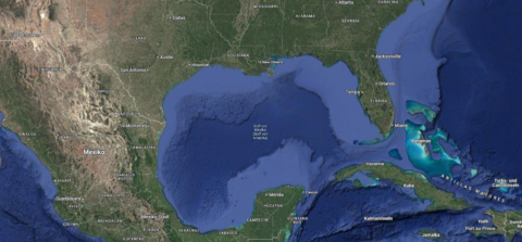
No ‘Gulf of Erlangen’ – doing geography like Donald Trump?