ESPON InTerAlp – Interface territories across the Alpine region

The InTerAlp project, funded by ESPON EGTC, examines interface territories across the Alpine region. Alpine ‘interface territories’ are a highly relevant and interesting spatial category. By linking mountainous and inner-Alpine areas with pre-Alpine lowlands, they are a very specific territorial type: Highly dynamic flows and interdependencies as well as controversial stakeholder interests meet in a rather limited spatial framework. Organizing sustainable spatial development in this geographical context is a challenge.
You can access the project reports:
- Final report
- Policy Brief
- Case study portfolio
- Spatial and sectoral governance in Alpine interface territories
Find the ESPON InTerAlp Case study portfolio storymap here.
Mapping Alpine interface territories: A new geography?
To start the video, click the button.
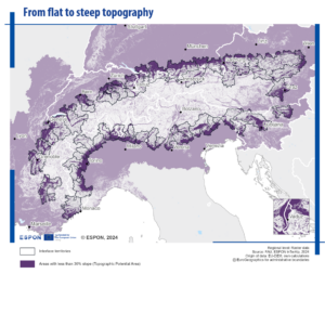
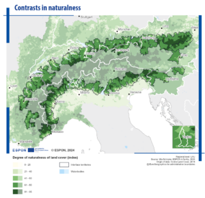
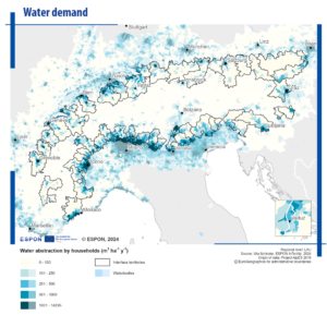
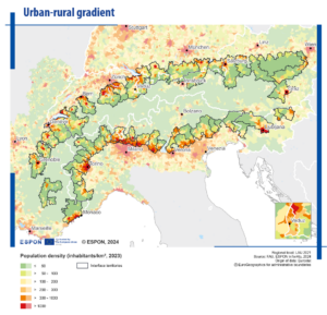
Interface areas across the Alpine region – territorial contrasts as challenge and potential
See more maps and visuals in the final report.
In order to provide a deeper analytical understanding and to produce policy-relevant results, the InTerAlp project focusses on questions and challenges related to the ‘interface territories’ of the Alpine region in a differentiated and rather complete way. The objective is to fill the research gaps and to promote sustainable development of the Alpine region. More concretely speaking, the project adopts three main perspectives:
- The geographical focus: The project’s spatial focus is on the Alpine Convention perimeter complemented by the adjacent, often highly urbanised zone that is functionally integrated (being part of the EUSALP perimeter). This region brings together a territorial diversity, including vulnerable high mountain areas and strong lowlands with often metropolitan cores. The level of territorial knowledge is rather high for some of the territorial categories (mountain areas, city regions etc.). However, the territorial development dynamics characterising those territories positioned between the inner- and the outer parts of the mountainous areas have not yet been systematically analysed. Often, these areas are considered ‘fringes’ from a mountain perspective or ‘periurban’ areas from the perspective of the main urban cores. Putting them in the centre of regional development and policy analyses is a new and original focus. The definition and concretization of interface territories will result from the analytical works of this project.
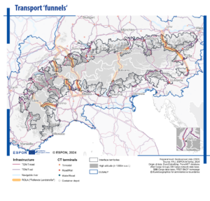
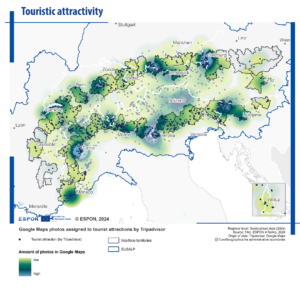
- The focus on flows and interlinkages: One reason why interface territories have not yet been prominently investigated, is related to data availability and quality. A good understanding of these territories asks for small-scale data, flow data, and cross-border data. This is due to the territorial specificities of the Alpine region, which is characterised by many national and regional borders (cp. ESPON Alps 2050). Moreover, small places matter a lot in the territorial organisation of the region, and this comes along with a small-scale complexity. This kind of data is not easily available from official statistics and raises questions of harmonisation. The InTerAlp project addresses the data gaps in a creative, original and solid way. Meaningful ESPON data and regional statistics will be combined with ‘new data’ in form of accessibility measures, social media etc.
- The governance focus: The promotion of integrated territorial development requires adopting a comprehensive, cross-sectoral governance approach. In the Alpine region, this is particularly challenging, again due to the high number of national and regional borders. In consequence, the numerous institutions are, in one way or another, involved in spatial governance and planning activities. At the domestic level, ‘hard’ (statutory) forms of spatial planning play an important role (municipalities, provinces, regions and states). At the pan-Alpine level, spatial development has to be addressed on a larger scale, through soft strategic tools often characterised by fuzzy, flexible boundaries. This comes along with the challenge to link the different territorial levels and establish synergies and cross-fertilisation among the different types of instruments (strategies, visions, programmes, regulations etc).